
Tropical Sea Temperatures
Visit Weather Underground Tropical Weather Center
Atlantic/Gulf of Mexico/Caribbean
Atlantic Tropical Weather Outlook
000
ABNT20 KNHC 221129
TWOAT

Tropical Weather Outlook
NWS National Hurricane Center Miami FL
800 AM EDT Tue Oct 22 2024

For the North Atlantic...Caribbean Sea and the Gulf of Mexico:

Active Systems:
The National Hurricane Center is issuing advisories on Tropical
Storm Oscar, located near the central and southeastern Bahamas.

Tropical cyclone formation is not expected during the next 7 days.

$$
Forecaster Papin
Summary for Tropical Storm Oscar (AT1/AL162024)
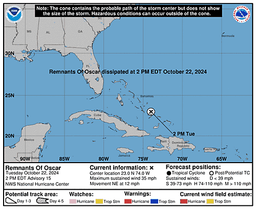
...OSCAR CONTINUES MOVING THROUGH THE CENTRAL AND SOUTHEASTERN  BAHAMAS...
 As of 8:00 AM EDT Tue Oct 22
 the center of Oscar was located near 22.8, -74.7
 with movement NE at 12 mph.
 The minimum central pressure was 1006 mb
 with maximum sustained winds of about 40 mph.
Tropical Storm Oscar Public Advisory Number 13A
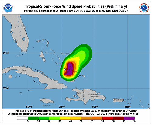
Issued at 800 AM EDT Tue Oct 22 2024
ZCZC MIATCPAT1 ALL
TTAA00 KNHC DDHHMM

BULLETIN
Tropical Storm Oscar Intermediate Advisory Number 13A
NWS National Hurricane Center Miami FL       AL162024
800 AM EDT Tue Oct 22 2024

...OSCAR CONTINUES MOVING THROUGH THE CENTRAL AND SOUTHEASTERN
BAHAMAS...


SUMMARY OF 800 AM EDT...1200 UTC...INFORMATION
----------------------------------------------
LOCATION...22.8N 74.7W
ABOUT 45 MI...75 KM SE OF LONG ISLAND
MAXIMUM SUSTAINED WINDS...40 MPH...65 KM/H
PRESENT MOVEMENT...NE OR 35 DEGREES AT 12 MPH...19 KM/H
MINIMUM CENTRAL PRESSURE...1006 MB...29.71 INCHES


WATCHES AND WARNINGS
--------------------
CHANGES WITH THIS ADVISORY:

None.

SUMMARY OF WATCHES AND WARNINGS IN EFFECT:

A Tropical Storm Warning is in effect for...
* Central Bahamas
* Southeastern Bahamas

A Tropical Storm Warning means that tropical storm conditions are
expected somewhere within the warning area.

For storm information specific to your area, please monitor
products issued by your national meteorological service.


DISCUSSION AND OUTLOOK
----------------------
At 800 AM EDT (1200 UTC), the center of Tropical Storm Oscar was
located near latitude 22.8 North, longitude 74.7 West.  Oscar is
moving toward the northeast near 12 mph (19 km/h).  A faster
northeastward motion is expected later today and on Wednesday.  On
the forecast track, the center of Oscar is expected to move near the
southeastern and central Bahamas today, then move away from the
Bahamas tonight and Wednesday.

Maximum sustained winds are near 40 mph (65 km/h) with higher gusts.
Little change in strength is forecast during the day today. Oscar is
expected to become a post-tropical low by tonight or early
Wednesday, and then be absorbed by another low pressure area by
Thursday.

Tropical-storm-force winds extend outward up to 105 miles (165 km)
east and northeast of the center.

The estimated minimum central pressure is 1006 mb (29.71 inches).


HAZARDS AFFECTING LAND
----------------------
Key messages for Oscar can be found in the Tropical Cyclone
Discussion under AWIPS header MIATCDAT1 and WMO header WTNT41 KNHC
and on the web at hurricanes.gov/text/MIATCDAT1.shtml

WIND: Tropical storm conditions are expected in the warning area in
parts of the central and southeastern Bahamas today.

RAINFALL: Across the southeastern Bahamas and the Turks and Caicos
Islands, rainfall amounts of 3 to 5 inches, with isolated amounts
around 8 inches, are expected through today. This rainfall could
cause localized flash flooding.

For a complete depiction of forecast rainfall associated with Oscar,
please see the National Weather Service Storm Total Rainfall
Graphic, available at hurricanes.gov/graphics_at1.shtml?rainqpf.


NEXT ADVISORY
-------------
Next complete advisory at 1100 AM EDT.

$$
Forecaster Pasch

NNNN
Tropical Storm Oscar Forecast Advisory Number 13
Issued at 0900 UTC TUE OCT 22 2024

000
WTNT21 KNHC 220831
TCMAT1

TROPICAL STORM OSCAR FORECAST/ADVISORY NUMBER  13
NWS NATIONAL HURRICANE CENTER MIAMI FL       AL162024
0900 UTC TUE OCT 22 2024

TROPICAL STORM CENTER LOCATED NEAR 22.7N  74.8W AT 22/0900Z
POSITION ACCURATE WITHIN  30 NM

PRESENT MOVEMENT TOWARD THE NORTH-NORTHEAST OR  30 DEGREES AT  10 KT

ESTIMATED MINIMUM CENTRAL PRESSURE 1006 MB
MAX SUSTAINED WINDS  35 KT WITH GUSTS TO  45 KT.
34 KT....... 90NE  90SE   0SW   0NW.
12 FT SEAS..  0NE  60SE   0SW   0NW.
WINDS AND SEAS VARY GREATLY IN EACH QUADRANT.  RADII IN NAUTICAL
MILES ARE THE LARGEST RADII EXPECTED ANYWHERE IN THAT QUADRANT.

REPEAT...CENTER LOCATED NEAR 22.7N  74.8W AT 22/0900Z
AT 22/0600Z CENTER WAS LOCATED NEAR 22.3N  75.1W

FORECAST VALID 22/1800Z 23.8N  73.8W
MAX WIND  35 KT...GUSTS  45 KT.
34 KT... 80NE  80SE   0SW   0NW.

FORECAST VALID 23/0600Z 25.7N  71.7W...POST-TROPICAL
MAX WIND  35 KT...GUSTS  45 KT.
34 KT... 40NE  80SE   0SW   0NW.

FORECAST VALID 23/1800Z 28.5N  69.5W...POST-TROP/EXTRATROP
MAX WIND  35 KT...GUSTS  45 KT.
34 KT... 40NE  80SE   0SW   0NW.

FORECAST VALID 24/0600Z...DISSIPATED

REQUEST FOR 3 HOURLY SHIP REPORTS WITHIN 300 MILES OF 22.7N  74.8W

INTERMEDIATE PUBLIC ADVISORY...WTNT31 KNHC/MIATCPAT1...AT 22/1200Z

NEXT ADVISORY AT 22/1500Z

$$
FORECASTER BEVEN
Tropical Storm Oscar Forecast Discussion Number 13
Issued at 500 AM EDT Tue Oct 22 2024

000
WTNT41 KNHC 220833
TCDAT1

Tropical Storm Oscar Discussion Number  13
NWS National Hurricane Center Miami FL       AL162024
500 AM EDT Tue Oct 22 2024

Oscar is at best barely a tropical storm at this time.  While
convection associated with the system has increased since the last
advisory, most of it is occurring in clusters well away from the
center in the eastern semicircle, and there is only minimal
convection near the center.  Also, while 850 mb flight-level winds
were as high as 45-50 kt during an earlier Air Force Reserve
Hurricane Hunter mission, dropsonde and SFMR data suggests those
winds were having trouble mixing down to the surface.  The system
will be maintained as a 35-kt tropical storm pending the next recon
flight and whether convection will increase further during the
upcoming diurnal maximum.

The global models are in good agreement that a developing mid- to
upper-level trough over the southwestern Atlantic will cause
baroclinic cyclogenesis near or north of Oscar during the next
24-48 h.  The UKMET shows Oscar become the main focus for the
development and becoming a large extratropical low, while the GFS
develops a second low to the north of Oscar with Oscar becoming
absorbed into the new system.  The ECMWF and Canadian models
forecast a blend of these scenarios, with the baroclinic low forming
close to Oscar.  Given Oscar's organization and current trends in
satellite imagery, the intensity forecast leans towards the GFS
solution, with Oscar becoming a post-tropical low in less than 24 h
and then being absorbed by the new low in 36-48 h.

The initial motion is now 030/10 kt.  Interaction with the above
mentioned trough should steer Oscar generally northeastward with an
increase in forward speed until it is absorbed by the new
baroclinic low.  The new forecast track is similar to the previous
track.


Key Messages:

1. Through Tuesday, localized flash flooding will be possible across
the southeastern Bahamas as well as the Turks and Caicos Islands.
With rainfall easing across Cuba, flooding from rainfall which has
already occurred could remain a concern for the next several days.

2. Tropical storm conditions are expected in portions of the
southeastern and central Bahamas today.


FORECAST POSITIONS AND MAX WINDS

INIT  22/0900Z 22.7N  74.8W   35 KT  40 MPH
 12H  22/1800Z 23.8N  73.8W   35 KT  40 MPH
 24H  23/0600Z 25.7N  71.7W   35 KT  40 MPH...POST-TROPICAL
 36H  23/1800Z 28.5N  69.5W   35 KT  40 MPH...POST-TROP/EXTRATROP
 48H  24/0600Z...DISSIPATED

$$
Forecaster Beven
Tropical Storm Oscar Wind Speed Probabilities Number 13
Issued at 0900 UTC TUE OCT 22 2024

000
FONT11 KNHC 220832
PWSAT1

TROPICAL STORM OSCAR WIND SPEED PROBABILITIES NUMBER  13
NWS NATIONAL HURRICANE CENTER MIAMI FL       AL162024
0900 UTC TUE OCT 22 2024

AT 0900Z THE CENTER OF TROPICAL STORM OSCAR WAS LOCATED NEAR
LATITUDE 22.7 NORTH...LONGITUDE 74.8 WEST WITH MAXIMUM SUSTAINED
WINDS NEAR 35 KTS...40 MPH...65 KM/H.

Z INDICATES COORDINATED UNIVERSAL TIME (GREENWICH)
   ATLANTIC STANDARD TIME (AST)...SUBTRACT 4 HOURS FROM Z TIME
   EASTERN  DAYLIGHT TIME (EDT)...SUBTRACT 4 HOURS FROM Z TIME
   CENTRAL  DAYLIGHT TIME (CDT)...SUBTRACT 5 HOURS FROM Z TIME

WIND SPEED PROBABILITY TABLE FOR SPECIFIC LOCATIONS

CHANCES OF SUSTAINED (1-MINUTE AVERAGE) WIND SPEEDS OF AT LEAST
   ...34 KT (39 MPH... 63 KM/H)...
   ...50 KT (58 MPH... 93 KM/H)...
   ...64 KT (74 MPH...119 KM/H)...
FOR LOCATIONS AND TIME PERIODS DURING THE NEXT 5 DAYS

PROBABILITIES FOR LOCATIONS ARE GIVEN AS OP(CP) WHERE
    OP  IS THE PROBABILITY OF THE EVENT BEGINNING DURING
        AN INDIVIDUAL TIME PERIOD (ONSET PROBABILITY)
   (CP) IS THE PROBABILITY OF THE EVENT OCCURRING BETWEEN
        06Z TUE AND THE FORECAST HOUR (CUMULATIVE PROBABILITY)

PROBABILITIES ARE GIVEN IN PERCENT
X INDICATES PROBABILITIES LESS THAN 1 PERCENT
PROBABILITIES FOR 34 KT AND 50 KT ARE SHOWN AT A GIVEN LOCATION WHEN
THE 5-DAY CUMULATIVE PROBABILITY IS AT LEAST 3 PERCENT.
PROBABILITIES FOR 34...50...64 KT SHOWN WHEN THE 5-DAY
64-KT CUMULATIVE PROBABILITY IS AT LEAST 1 PERCENT.


  - - - - WIND SPEED PROBABILITIES FOR SELECTED LOCATIONS - - - -

               FROM    FROM    FROM    FROM    FROM    FROM    FROM
  TIME       06Z TUE 18Z TUE 06Z WED 18Z WED 06Z THU 06Z FRI 06Z SAT
PERIODS         TO      TO      TO      TO      TO      TO      TO
             18Z TUE 06Z WED 18Z WED 06Z THU 06Z FRI 06Z SAT 06Z SUN

FORECAST HOUR    (12)   (24)    (36)    (48)    (72)    (96)   (120)
- - - - - - - - - - - - - - - - - - - - - - - - - - - - - - - - - -
LOCATION       KT

SAN SALVADOR   34 15   1(16)   X(16)   X(16)   X(16)   X(16)   X(16)

MAYAGUANA      34 17   X(17)   X(17)   X(17)   X(17)   X(17)   X(17)

$$
FORECASTER BEVEN
Tropical Storm Oscar Graphics
5-Day Uncertainty Track last updated Tue, 22 Oct 2024 11:58:43 GMT
Wind Speed Probabilities last updated Tue, 22 Oct 2024 09:22:54 GMT
Eastern Pacific
Eastern North Pacific Tropical Weather Outlook
310
ABPZ20 KNHC 221120
TWOEP

Tropical Weather Outlook
NWS National Hurricane Center Miami FL
500 AM PDT Tue Oct 22 2024

For the eastern North Pacific...east of 140 degrees west longitude:

Active Systems:
The National Hurricane Center is issuing advisories on Tropical
Storm Kristy, located a few hundred miles south-southwest of the
southwestern coast of Mexico.

Tropical cyclone formation is not expected during the next 7 days.

&&
Public Advisories on Tropical Storm Kristy are issued under WMO
header WTPZ32 KNHC and under AWIPS header MIATCPEP2.
Forecast/Advisories on Tropical Storm Kristy are issued under WMO
header WTPZ22 KNHC and under AWIPS header MIATCMEP2.

$$
Forecaster Papin
Summary for Tropical Storm Kristy (EP2/EP122024)
...KRISTY CONTINUES TO STRENGTHEN...
 As of 3:00 AM CST Tue Oct 22
 the center of Kristy was located near 14.2, -104.8
 with movement WNW at 15 mph.
 The minimum central pressure was 1001 mb
 with maximum sustained winds of about 50 mph.
Tropical Storm Kristy Public Advisory Number 3
Issued at 300 AM CST Tue Oct 22 2024

264
WTPZ32 KNHC 220834
TCPEP2

BULLETIN
Tropical Storm Kristy Advisory Number   3
NWS National Hurricane Center Miami FL       EP122024
300 AM CST Tue Oct 22 2024

...KRISTY CONTINUES TO STRENGTHEN...


SUMMARY OF 300 AM CST...0900 UTC...INFORMATION
----------------------------------------------
LOCATION...14.2N 104.8W
ABOUT 375 MI...605 KM WSW OF ACAPULCO MEXICO
ABOUT 520 MI...835 KM SE OF SOCORRO ISLAND
MAXIMUM SUSTAINED WINDS...50 MPH...85 KM/H
PRESENT MOVEMENT...WNW OR 285 DEGREES AT 15 MPH...24 KM/H
MINIMUM CENTRAL PRESSURE...1001 MB...29.56 INCHES


WATCHES AND WARNINGS
--------------------
There are no coastal watches or warnings in effect.


DISCUSSION AND OUTLOOK
----------------------
At 300 AM CST (0900 UTC), the center of Tropical Storm Kristy was
located near latitude 14.2 North, longitude 104.8 West. Kristy is
moving toward the west-northwest near 15 mph (24 km/h). A westward
motion is expected for the next few days.

Maximum sustained winds have increased to near 50 mph (85 km/h)
with higher gusts. Steady strengthening is forecast during the next
few days, and Kristy is forecast to become a hurricane by tonight.

Tropical-storm-force winds extend outward up to 60 miles (95 km)
from the center.

The estimated minimum central pressure is 1001 mb (29.56 inches).


HAZARDS AFFECTING LAND
----------------------
None.


NEXT ADVISORY
-------------
Next complete advisory at 900 AM CST.

$$
Forecaster Hagen
Tropical Storm Kristy Forecast Advisory Number 3
Issued at 0900 UTC TUE OCT 22 2024

000
WTPZ22 KNHC 220833
TCMEP2

TROPICAL STORM KRISTY FORECAST/ADVISORY NUMBER   3
NWS NATIONAL HURRICANE CENTER MIAMI FL       EP122024
0900 UTC TUE OCT 22 2024

TROPICAL STORM CENTER LOCATED NEAR 14.2N 104.8W AT 22/0900Z
POSITION ACCURATE WITHIN  30 NM

PRESENT MOVEMENT TOWARD THE WEST-NORTHWEST OR 285 DEGREES AT  13 KT

ESTIMATED MINIMUM CENTRAL PRESSURE 1001 MB
MAX SUSTAINED WINDS  45 KT WITH GUSTS TO  55 KT.
34 KT....... 50NE   0SE   0SW  50NW.
12 FT SEAS.. 90NE  30SE  30SW  60NW.
WINDS AND SEAS VARY GREATLY IN EACH QUADRANT.  RADII IN NAUTICAL
MILES ARE THE LARGEST RADII EXPECTED ANYWHERE IN THAT QUADRANT.

REPEAT...CENTER LOCATED NEAR 14.2N 104.8W AT 22/0900Z
AT 22/0600Z CENTER WAS LOCATED NEAR 14.1N 104.0W

FORECAST VALID 22/1800Z 14.3N 107.1W
MAX WIND  60 KT...GUSTS  75 KT.
50 KT... 20NE   0SE   0SW   0NW.
34 KT... 60NE  30SE  20SW  60NW.

FORECAST VALID 23/0600Z 14.4N 110.4W
MAX WIND  70 KT...GUSTS  85 KT.
64 KT... 10NE   0SE   0SW   0NW.
50 KT... 20NE  15SE   0SW  15NW.
34 KT... 60NE  40SE  40SW  60NW.

FORECAST VALID 23/1800Z 14.3N 113.8W
MAX WIND  85 KT...GUSTS 105 KT.
64 KT... 15NE  10SE   0SW  10NW.
50 KT... 30NE  20SE  15SW  20NW.
34 KT... 70NE  50SE  50SW  70NW.

FORECAST VALID 24/0600Z 14.2N 117.2W
MAX WIND  95 KT...GUSTS 115 KT.
64 KT... 20NE  15SE  10SW  15NW.
50 KT... 40NE  30SE  20SW  30NW.
34 KT... 80NE  60SE  60SW  80NW.

FORECAST VALID 24/1800Z 14.3N 120.3W
MAX WIND 100 KT...GUSTS 120 KT.
50 KT... 40NE  30SE  30SW  40NW.
34 KT... 90NE  70SE  70SW  90NW.

FORECAST VALID 25/0600Z 14.8N 123.0W
MAX WIND 100 KT...GUSTS 120 KT.
50 KT... 50NE  40SE  30SW  50NW.
34 KT...100NE  80SE  70SW 100NW.

EXTENDED OUTLOOK. NOTE...ERRORS FOR TRACK HAVE AVERAGED NEAR 100 NM
ON DAY 4 AND 125 NM ON DAY 5...AND FOR INTENSITY NEAR 15 KT EACH DAY

OUTLOOK VALID 26/0600Z 17.1N 127.9W
MAX WIND  90 KT...GUSTS 110 KT.
50 KT... 60NE  40SE  30SW  50NW.
34 KT...110NE  90SE  70SW 110NW.

OUTLOOK VALID 27/0600Z 20.3N 131.6W
MAX WIND  65 KT...GUSTS  80 KT.
50 KT... 40NE  40SE  30SW  40NW.
34 KT...110NE  70SE  60SW 100NW.

REQUEST FOR 3 HOURLY SHIP REPORTS WITHIN 300 MILES OF 14.2N 104.8W

NEXT ADVISORY AT 22/1500Z

$$
FORECASTER HAGEN
Tropical Storm Kristy Forecast Discussion Number 3
Issued at 300 AM CST Tue Oct 22 2024

000
WTPZ42 KNHC 220835
TCDEP2

Tropical Storm Kristy Discussion Number   3
NWS National Hurricane Center Miami FL       EP122024
300 AM CST Tue Oct 22 2024

Satellite images indicate that Kristy has continued to gradually
become better organized during the overnight hours.  A convective
burst has been occurring over the low-level center, an indication
that a central core could be forming.  The cyclone also has some
impressive curved banding to the north and west, although these
bands are a bit far from the center.  A pair of ASCAT passes from
22/0346 UTC and 22/0441 UTC showed tropical storm force winds in
the northern semi-circle, with vectors in the 35 to 38 kt range.
Since the time of the ASCAT passes, Kristy's convection has become
better organized, with latest subjective Dvorak intensity estimates
from TAFB and SAB at a consensus T-3.0/45 kt.  The initial intensity
is nudged upward to 45 kt for this advisory.

Kristy is estimated to be moving west-northwestward, or 285/13 kt.
A strong subtropical ridge to the north of the cyclone will steer
it westward for the next 3 days or so.  Friday into the weekend, a
turn to the west-northwest or northwest is expected as Kristy rounds
the western periphery of the mid to upper-level ridge, and a
mid-latitude upper-level trough approaches from the west.  The track
forecast is largely unchanged from the previous official forecast
and lies in the middle of the guidance envelope.  It should be noted
that there is quite a bit of spread in the track guidance at days 4
and 5, so confidence in this part of the forecast is a bit below
average.

Environmental conditions are favorable for steady strengthening,
and rapid intensification cannot be ruled out.  For the next
72 h, Kristy will remain within an environment of warm ocean
temperatures, relatively weak vertical wind shear, and a moist
troposphere.  Beyond 72 h, southerly or southwesterly vertical wind
shear will begin to increase over the cyclone, becoming strong in 4
to 5 days.  Kristy should also cross the 26C isotherm in about 4
days and move into a much more stable environment.  Therefore,
weakening should begin in 3 to 4 days, with the potential for rapid
weakening in 4 to 5 days.  The intensity forecast is largely
unchanged from the previous prediction, which calls for Kristy to
peak at 100 kt in a few days, and lies near the middle of the
guidance envelope.


FORECAST POSITIONS AND MAX WINDS

INIT  22/0900Z 14.2N 104.8W   45 KT  50 MPH
 12H  22/1800Z 14.3N 107.1W   60 KT  70 MPH
 24H  23/0600Z 14.4N 110.4W   70 KT  80 MPH
 36H  23/1800Z 14.3N 113.8W   85 KT 100 MPH
 48H  24/0600Z 14.2N 117.2W   95 KT 110 MPH
 60H  24/1800Z 14.3N 120.3W  100 KT 115 MPH
 72H  25/0600Z 14.8N 123.0W  100 KT 115 MPH
 96H  26/0600Z 17.1N 127.9W   90 KT 105 MPH
120H  27/0600Z 20.3N 131.6W   65 KT  75 MPH

$$
Forecaster Hagen
Tropical Storm Kristy Wind Speed Probabilities Number 3
Issued at 0900 UTC TUE OCT 22 2024

000
FOPZ12 KNHC 220834
PWSEP2

TROPICAL STORM KRISTY WIND SPEED PROBABILITIES NUMBER   3
NWS NATIONAL HURRICANE CENTER MIAMI FL       EP122024
0900 UTC TUE OCT 22 2024

AT 0900Z THE CENTER OF TROPICAL STORM KRISTY WAS LOCATED NEAR
LATITUDE 14.2 NORTH...LONGITUDE 104.8 WEST WITH MAXIMUM SUSTAINED
WINDS NEAR 45 KTS...50 MPH...85 KM/H.

Z INDICATES COORDINATED UNIVERSAL TIME (GREENWICH)
   PACIFIC  DAYLIGHT TIME (PDT)...SUBTRACT 7 HOURS FROM Z TIME
   HAWAIIAN STANDARD TIME (HST)...SUBTRACT 10 HOURS FROM Z TIME

WIND SPEED PROBABILITY TABLE FOR SPECIFIC LOCATIONS

CHANCES OF SUSTAINED (1-MINUTE AVERAGE) WIND SPEEDS OF AT LEAST
   ...34 KT (39 MPH... 63 KM/H)...
   ...50 KT (58 MPH... 93 KM/H)...
   ...64 KT (74 MPH...119 KM/H)...
FOR LOCATIONS AND TIME PERIODS DURING THE NEXT 5 DAYS

PROBABILITIES FOR LOCATIONS ARE GIVEN AS OP(CP) WHERE
    OP  IS THE PROBABILITY OF THE EVENT BEGINNING DURING
        AN INDIVIDUAL TIME PERIOD (ONSET PROBABILITY)
   (CP) IS THE PROBABILITY OF THE EVENT OCCURRING BETWEEN
        06Z TUE AND THE FORECAST HOUR (CUMULATIVE PROBABILITY)

PROBABILITIES ARE GIVEN IN PERCENT
X INDICATES PROBABILITIES LESS THAN 1 PERCENT
PROBABILITIES FOR 34 KT AND 50 KT ARE SHOWN AT A GIVEN LOCATION WHEN
THE 5-DAY CUMULATIVE PROBABILITY IS AT LEAST 3 PERCENT.
PROBABILITIES FOR 34...50...64 KT SHOWN WHEN THE 5-DAY
64-KT CUMULATIVE PROBABILITY IS AT LEAST 1 PERCENT.


  - - - - WIND SPEED PROBABILITIES FOR SELECTED LOCATIONS - - - -

               FROM    FROM    FROM    FROM    FROM    FROM    FROM
  TIME       06Z TUE 18Z TUE 06Z WED 18Z WED 06Z THU 06Z FRI 06Z SAT
PERIODS         TO      TO      TO      TO      TO      TO      TO
             18Z TUE 06Z WED 18Z WED 06Z THU 06Z FRI 06Z SAT 06Z SUN

FORECAST HOUR    (12)   (24)    (36)    (48)    (72)    (96)   (120)
- - - - - - - - - - - - - - - - - - - - - - - - - - - - - - - - - -
LOCATION       KT

15N 105W       34 62   X(62)   X(62)   X(62)   X(62)   X(62)   X(62)

CLIPPERTON IS  34  1   2( 3)   1( 4)   X( 4)   X( 4)   X( 4)   X( 4)

10N 110W       34  X   3( 3)   X( 3)   X( 3)   X( 3)   X( 3)   X( 3)

15N 110W       34  2  87(89)   1(90)   X(90)   X(90)   X(90)   X(90)
15N 110W       50  X  48(48)   3(51)   X(51)   X(51)   X(51)   X(51)
15N 110W       64  X  16(16)   2(18)   X(18)   X(18)   X(18)   X(18)

ISLA SOCORRO   34  X   3( 3)   1( 4)   X( 4)   X( 4)   X( 4)   X( 4)

ISLA CLARION   34  X   X( X)   4( 4)   3( 7)   X( 7)   X( 7)   X( 7)

10N 115W       34  X   X( X)   3( 3)   1( 4)   X( 4)   X( 4)   X( 4)

15N 115W       34  X   2( 2)  55(57)  32(89)   X(89)   X(89)   X(89)
15N 115W       50  X   X( X)  17(17)  43(60)   X(60)   X(60)   X(60)
15N 115W       64  X   X( X)   4( 4)  29(33)   1(34)   X(34)   X(34)

10N 120W       34  X   X( X)   X( X)   1( 1)   4( 5)   X( 5)   X( 5)

15N 120W       34  X   X( X)   X( X)  18(18)  71(89)   X(89)   X(89)
15N 120W       50  X   X( X)   X( X)   3( 3)  58(61)   X(61)   X(61)
15N 120W       64  X   X( X)   X( X)   1( 1)  39(40)   X(40)   X(40)

20N 120W       34  X   X( X)   X( X)   X( X)   2( 2)   1( 3)   X( 3)

10N 125W       34  X   X( X)   X( X)   X( X)   2( 2)   1( 3)   X( 3)

15N 125W       34  X   X( X)   X( X)   X( X)  39(39)  35(74)   1(75)
15N 125W       50  X   X( X)   X( X)   X( X)  11(11)  32(43)   X(43)
15N 125W       64  X   X( X)   X( X)   X( X)   4( 4)  20(24)   1(25)

20N 125W       34  X   X( X)   X( X)   X( X)   1( 1)  12(13)   2(15)

15N 130W       34  X   X( X)   X( X)   X( X)   X( X)  13(13)   3(16)
15N 130W       50  X   X( X)   X( X)   X( X)   X( X)   2( 2)   1( 3)
15N 130W       64  X   X( X)   X( X)   X( X)   X( X)   1( 1)   X( 1)

20N 130W       34  X   X( X)   X( X)   X( X)   X( X)  15(15)  42(57)
20N 130W       50  X   X( X)   X( X)   X( X)   X( X)   3( 3)  23(26)
20N 130W       64  X   X( X)   X( X)   X( X)   X( X)   1( 1)  10(11)

25N 130W       34  X   X( X)   X( X)   X( X)   X( X)   X( X)   4( 4)

20N 135W       34  X   X( X)   X( X)   X( X)   X( X)   X( X)   9( 9)

25N 135W       34  X   X( X)   X( X)   X( X)   X( X)   X( X)   4( 4)

$$
FORECASTER HAGEN
Tropical Storm Kristy Graphics
5-Day Uncertainty Track last updated Tue, 22 Oct 2024 08:37:50 GMT
Wind Speed Probabilities last updated Tue, 22 Oct 2024 09:28:54 GMT